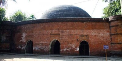
01
Sundarbans
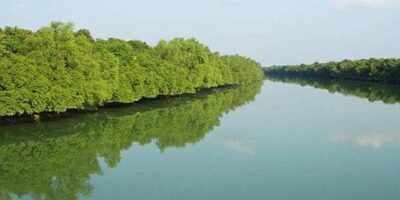
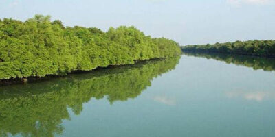
Sundarbans is a vast forest located on the coast of Bay of Bengal which is one of the natural wonders of the world. Located in the delta region of the Padma, Meghna and Brahmaputra river basins, this magnificent forest is spread across Khulna, Satkhira, Bagerhat, Patuakhali and Barguna districts of Bangladesh.
As the largest mangrove forest in coastal saline environment, Sundarbans is the largest intact forest in the world. Spread over 10,000 square kilometers, Sundarbans has 6,017 square kilometers in Bangladesh. Sundarbans was recognized as a UNESCO World Heritage Site in 1997.
Its Bangladeshi and Indian parts are in fact contiguous parts of the same unbroken landmass, but are listed under different names on the UNESCO World Heritage List; Named as “Sunderbans” and “Sunderbans National Park” respectively.
The Sundarbans is a web of small islands with ocean currents, mudflats and salinity of mangrove forests. 31.1 percent of the total forest area, i.e. 1,874 square kilometers, is covered by rivers, creeks, and wetlands.
The forest is known to be home to numerous species of birds, deer, crocodiles and snakes, apart from the eponymous Royal Bengal Tiger. According to the survey, there are 500 tigers and 30,000 blackbucks in the Sundarbans area. On May 21, 1992, Sundarbans was recognized as a Ramsar site.
Naming:
Sundarban in Bengali literally means beautiful forest or beautiful forest. The Sundarbans may have been named after the sundari tree, which grows abundantly there. Other possible explanations could be that it may have been named after “sea forest” or “Chandra-Bandhe (Bandhe)” (ancient aborigines). But it is generally assumed that Sundarbans got its name from the beautiful tree.
Geographical Structure:
A satellite image shows the protected forest area. Dark green shows the Sundarbans surrounded by light green agricultural land to the north, cities in copper and rivers in blue.
As one of the three largest mangrove forests in the entire world, the ecology of the Sundarbans in the Ganga basin is quite complex. The greater part (62%) of the Sundarbans is located in the south-western part of Bangladesh, extending across the two neighboring countries of Bangladesh and India.
The Bay of Bengal to the south; It is bounded by the Baleshwar River to the east and land of higher agricultural density to the north. Except for the main branches of the river in the highlands, the watercourses are everywhere largely blocked by embankments and low lands.
Actually the area of Sundarbans was supposed to be about 16,700 sq km. (As of 200 years ago). Its current size has gradually reduced to about one-third of its former size. At present the total land area is 4,143 sq km. (sands with an area of 42 sq km) and the rest of the watercourses including rivers, creeks and canals are 1,874 sq km. .
The rivers of Sundarbans are the meeting place of salt water and fresh water. So this area is the place between the fresh water of the river from the Ganga and the salt water of the Bay of Bengal. It covers Satkhira, Khulna, Bagerhat, Patuakhali region in Bangladesh.
Sundarbans is located in the south western region of Bangladesh. The Sundarbans have been formed over thousands of years by the deposition of sediments naturally separated from upstream by intercurrent flows along the Bay of Bengal. Its topography is deltaic, with numerous watercourses on the surface and mud walls and mudflats spreading across the bottom.
It also includes marginal grasslands, sandbars and islands above mean sea level, which are interwoven with canals, underwater mud walls, adipose mud and deposited sediments. The height of the Sundarbans from sea level varies from 0.9 m to 2.11 m.
Biological elements play an important role here in the structure of marine matter and animal diversity. Diverse areas like beaches, estuaries, permanent temporary wetlands, mudflats, creeks, sandbars, mudflats are formed here. Mangrove plants play a role in the formation of new land in the world itself. Again, intertidal plants play an important role in water morphogenesis.
The presence of mangrove fauna creates a unique morphological environment in intertidal mudflats. Holds the atypoly to form a horizontal substratum for the seed. The organization and evolution of sand dunes is controlled by abundant trees. Vines, grasses and hogs stabilize the structure of sandy and unconsolidated sediments.
Plant diversity:
Major forest species of Sundarbans include abundant Sundari, Gewa, Garan and Keora. According to Prain's calculations published in 1903, there are a total of 245 genera and 334 species of plants. Since Prain's report, there have been significant changes in the number of mangrove species and their taxonomy. Little research has been done on forest nature to account for these changes.
Bangladesh's mangrove forests differ widely in their plant life cycle compared to other non-deltavian coastal mangrove forests and upland forests. Rhizophoraceae are less important than the former. Differences in plant life cycles have been explained in terms of freshwater and low salinity effects in the northeast and drainage and sediment accumulation.
The Sundarbans are classified as a humid tropical forest that develops on well-developed beaches with keora and other coastal mangrove forests. It is true
Related Post

Warhammer RTS Realms of Wreck guarantees enhancements to unit stability, AI problem, controls and UI after “loud and clear” open beta suggestions
12:49:53pm 07-04-2025
Euro space month-to-month stability of payments_ Could 2023
12:47:56pm 07-04-2025
Photoshop’s new one-click AI simply shifted the steadiness of energy
12:45:12pm 07-04-2025
Mind-wide modifications in excitation-inhibition steadiness of main depressive disorder_ a scientific assessment of topographic patterns of GABA- and glutamatergic alterations
12:41:35pm 07-04-2025
Martin Lewis explains ‘two minute’ verify to chop ‘lots of’ off bank card curiosity
05:37:41pm 06-04-2025
Court docket overturns ruling on cost of safety account steadiness in concluded street work contract
02:47:27pm 06-04-2025Top Relate Post
The Sundarbans – Khulna
03:52:54pm 01-09-2023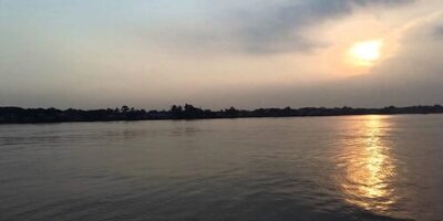
Khan Jahan Ali Bridge – khulna
03:57:06pm 01-09-2023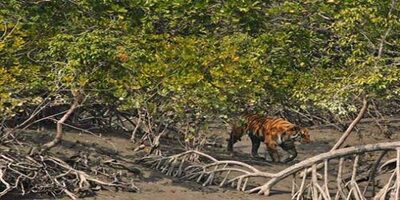
Katka Beach – Sundarban
03:59:53pm 01-09-2023
দুবলার চর – সুন্দরবন / Dublar Char – Sundarbans
04:18:08pm 01-09-2023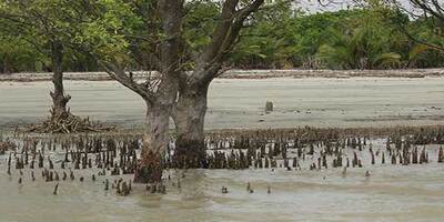
সুন্দরবনের কচিখালী সমুদ্র সৈকত / Kochikhali beach of Sundarbans
04:20:38pm 01-09-2023